
Geospatial Data Is Transforming Hotel Recommendations Beyond Star Ratings
The hotel search problem nobody talks about
For years, hotel discovery has leaned on the same familiar signals: star ratings, review averages, price, and photos. Those metrics are useful, but they often fail at the question travelers actually ask, sometimes without realizing it: “What will my days feel like if I stay here?”
A five star property can be perfect for a conference trip and frustrating for a weekend of café hopping. A charming boutique hotel might be highly rated, yet awkward for transit or parks. Reviews can hint at these issues, but they are subjective and slow to interpret at scale. This is where travel tech is taking a sharp turn. Instead of guessing from ratings, newer systems use location intelligence to measure the lived experience around a hotel.
Geospatial data makes it possible to evaluate what is truly nearby and how reachable it is on foot. When you combine that with traveler intent, recommendations stop being generic and start feeling tailored.
Why star ratings and reviews are no longer enough
Star ratings were never designed to match personal preferences. In many regions, stars reflect amenities and service standards, not whether the hotel suits a specific trip. Reviews help, but they introduce search problems:
- They reward popularity, which can drown out niche gems.
- They age quickly as neighborhoods change and businesses open or close.
- They vary by reviewer expectations and trip purpose.
From a ranking perspective, reviews are rich in detail but unreliable for consistent comparisons across cities and countries. That is why many platforms are moving toward measurable signals that can be updated automatically.
What geospatial data adds to hotel recommendations
Geospatial data is not just a map pin. It is a layer of information about place, movement, and environment. In hotel discovery, it enables three improvements.
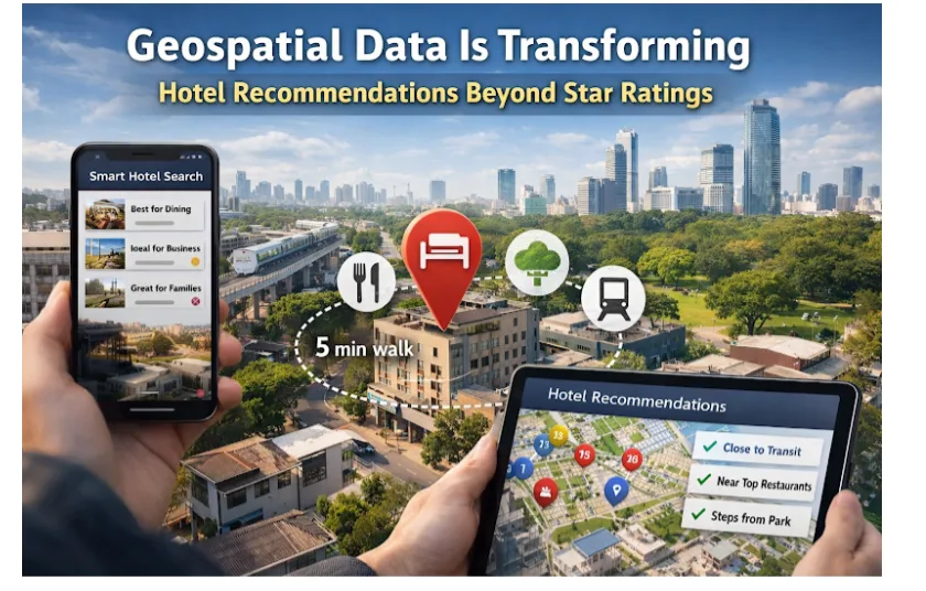
First, it turns proximity into a meaningful metric. “Near downtown” becomes a quantifiable distance to the places that matter: restaurants, business districts, landmarks, beaches, and transit hubs.
Second, it introduces walkability and routing, not just straight line distance. A hotel might be 600 meters from a museum, but if the route crosses a busy road or lacks sidewalks, the experience is different. This is the logic behind a walkability hotel search that evaluates whether a neighborhood supports easy movement.
Third, it captures neighborhood context. Quiet residential streets, nightlife zones, family friendly parks, or shopping corridors can change whether the same property feels right for different travelers.
Together, these signals allow geospatial hotel ranking models to behave more like a knowledgeable local.
The shift from “best hotel” to “best hotel for you”
The most important change is philosophical. Classic sorting assumes there is one universal best option. Intent based ranking assumes every trip has a goal, and “best” depends on the goal.
Traveler intent can be explicit, like “business trip near a metro line,” or implicit, like browsing central hotels and checking restaurant photos. Modern systems translate intent into scoring criteria. For example:
- A business traveler may prioritize transit access and proximity to offices.
- A couple on a short getaway may value walkability to dining and nightlife.
- A family might want parks and quick access to kid friendly attractions.
With geospatial data, these needs become measurable. The result is a ranking that adapts to traveler type rather than forcing everyone into the same list.
How modern hotel scoring actually works
Location driven models often follow a clear pipeline.
It starts with points of interest: restaurants, cafés, museums, parks, stations, venues, and more. Those points are grouped by relevance to different trip types. Next comes routing: how long it takes to walk or ride from the hotel to each category. Then comes weighting: how important each category is for the traveler persona.
A simplified scoring approach looks like this:
- Identify intent or persona for the search
- Select relevant categories of nearby places
- Compute walk times or transit times to each category
- Add neighborhood context features like density and noise proxies
- Produce a final score and rank hotels accordingly
This is why the conversation has moved beyond “is it close?” to “is it convenient in the way this traveler cares about?”
Where traveler personas fit in
Personas create consistency. Instead of building a one off ranking for every search, platforms can define a set of traveler types and map each to a scoring recipe. This makes it easier to test, explain, and improve recommendations.
Tripvento is a B2B travel API that ranks hotels based on traveler intent. Instead of sorting by price or stars, it scores hotels against 14 traveler personas using proximity, walkability, and neighborhood context. It covers 200 plus destinations across 25 plus countries. For partners, this approach can reduce guesswork and help deliver a more relevant hotel list without building an entire geospatial stack in house.
Personas also help with on site messaging. A platform can label results in ways that match real behavior, such as “ideal for food focused weekends,” which improves trust because users see why a recommendation fits.
Real world use cases for geospatial hotel ranking
Location aware scoring solves practical challenges across the travel funnel.
Better discovery in unfamiliar cities
When travelers do not know a city, they cannot judge neighborhoods. A map based score can surface hotels that sit in the right pocket for the trip, even if the traveler does not recognize street names.
Smarter filters that actually help
Many hotel filters are blunt: “city center,” “near beach,” “near airport.” Geospatial signals enable filters that reflect reality, such as:
- 10 minute walk to dining clusters
- under 15 minutes to major transit lines
- park access within a short stroll
That turns filtering into guidance rather than friction.
More accurate value perception
A hotel that looks expensive may be a good deal if it saves time and transportation. Conversely, a cheap hotel can become costly once you factor in long rides. Walkability hotel search features help travelers understand value in terms of time, not just money.
Implementation tips for travel platforms and product teams
Geospatial scoring offers a competitive edge, but only when implemented thoughtfully. Practical principles that tend to work:
- Start with one or two intent segments and validate that rankings improve engagement.
- Use walking time and transit time, not straight line distance, wherever possible.
- Keep the explanation layer simple. Show a few clear reasons a hotel fits.
- Refresh points of interest data regularly, especially in fast changing districts.
Many teams integrate specialized providers rather than building everything internally. The key is to keep ranking logic transparent enough that you can tune it for your audience.
How to communicate location intelligence to users
Even ranking models can fail if travelers do not understand them. The goal is to make location intelligence feel intuitive.
Use micro copy that reflects the traveler’s goal. If someone is browsing for a weekend break, emphasize walkable restaurants and attractions. If they are searching for a work trip, highlight easy transit and business district access.
Use compact visuals like walking time chips or neighborhood tags. Avoid overwhelming users with maps and numbers. A small set of cues builds confidence and reduces decision fatigue.
The road ahead for hotel discovery
Geospatial ranking will keep evolving as apps blend multiple signals into one experience. Expect more personalization that learns from past stays, and clearer scoring that shows tradeoffs.
The big change is that hotel discovery is becoming place aware. Travelers do not just book a building. They book an area and rhythm. The platforms that win will be the ones that model that reality and present it in a way that feels natural.