
Online Air Alert Maps of Ukraine and How to Read Them
The U.S. State Department keeps Ukraine at Level 4, Do Not Travel. The U.S. Embassy in Kyiv repeated that advice on November 17, 2026. Its security alert cited attacks on critical civilian infrastructure. Aid workers and journalists still make the trip. So do people with family in the country. If you are one of them, set up an alert map before you cross the border.
What do yellow and red mean on an air alert map?
Ukraine split its air raid alert into two levels in September 2026. Yellow marks a drone threat. Businesses and public transport may keep running if a shelter is within reach. Red marks a missile threat, a combined attack or a massive drone raid. Work stops and people head for shelter. Kyiv switched to the system on September 6, the city administration said.
The maps below use the same two colors. A yellow region beside a red one tells you the type of threat before you read a word.
Which maps show alerts across Ukraine?
Air Alert is the official app. Ajax Systems and Stfalcon built it in March 2022 with support from the Ministry of Digital Transformation. It runs in English and Ukrainian. Newsweek puts its daily audience at more than 6.6 million people. On October 17 the Cabinet of Ministers announced a new feature, a map of drone and missile movement inside the app.
Two weeks later attackers broke in. At about 22:47 Kyiv time on November 1, phones across the country showed false warnings of radiation and chemical threats. The developers switched off push notifications and suspended the app that night. Target tracking returned in mid-November behind identity verification through Diia, the state’s digital document app. Alerts, threat levels and the shelter map still work without it, the ministry says. Diia relies on Ukrainian documents, so most short-term visitors cannot pass the check.
Alerts.in.ua is the volunteer-built alternative. It has run since March 2022 and added an English version that September. Its map shades the regions and districts under alert. During the November 1 attack its team counted 122 bogus alert events in seven minutes, Newsweek reported.
An English map from a Kyiv travel project
Visit Kyiv, a city guide run by locals, launched an air alert map Ukraine travelers can read in English. Kyiv news site Big Kyiv reported the launch on November 3. Co-founder Tetiana Liuta said foreigners often tell the team they lack an alert map in English. Monitoring channels post in Ukrainian.
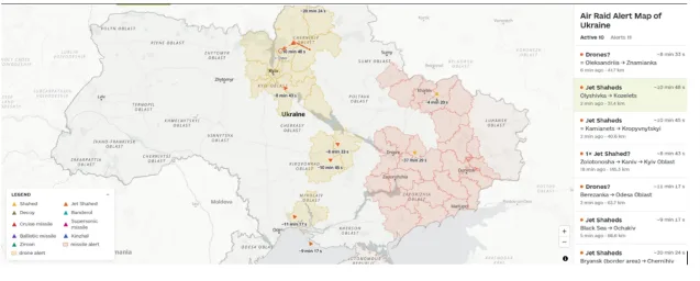
The map takes alert status from an official API and colors regions yellow or red. Markers show airborne targets reported by the Ukrainian Air Force and by volunteer Telegram channels. Tap a marker to see the target type, its route and an estimated time to arrival. A list beside the map repeats every active target. A sample entry reads Jet Shaheds, Olyshivka to Kozelets, 37.4 km, about 10 min 48 s. The legend separates Shahed drones from decoys and cruise missiles from ballistic ones. The map runs in a browser on a phone or a laptop.
Can you trust the arrival times?
Treat them as estimates. The map has no radar feed. It works out a target’s position from Telegram reports, average speed and the last reported course. Drones and missiles change direction. Reports arrive late, and the countdown ignores air defense. Visit Kyiv states all of this on the page, and that frankness makes the map easier to trust.
Two cases confuse new users. An empty map during an active alert means monitoring channels have reported nothing yet. Danger may still be present. A marker can vanish because reports stopped coming. That alone is no all-clear.
How should you use a map during an alert?
Use it to plan your movements and leave shelter decisions to the official alert. Liuta told Big Kyiv she checks for Shaheds heading toward the capital before she crosses the river, then picks the metro or surface transport. If an alert sounds, go to the nearest shelter whatever the markers show.
After November 1, keep two sources open. Air Alert or the city’s Kyiv Digital app sends notifications, and a browser map adds the wider picture. Sirens in Ukraine no longer sound for the all-clear, so check your app before leaving the shelter.