
RTK Navigation: Transforming Agriculture Through Precision Farming Technology
Modern farms are cutting costs by 20% with GNSS technology—here’s what you need to know
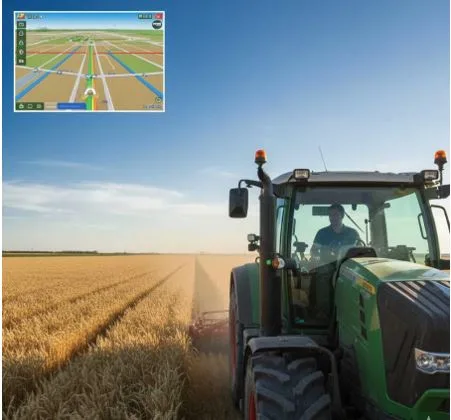
Walk onto any progressive farm today, and you’ll likely see something that would have seemed like science fiction twenty years ago: tractors driving themselves with centimeter-level accuracy, guided by satellites orbiting 20,000 kilometers above Earth. This isn’t futuristic fantasy—it’s the current reality of precision agriculture, and it’s changing how farms operate worldwide.
RTK Navigation specializes in these systems, providing farmers with technology that’s become essential rather than optional. But what makes GNSS navigation so critical for modern agriculture?
The Problem Traditional Farming Faces
Any experienced farmer knows the challenge: when you’re working a 200-hectare field, maintaining perfectly straight rows without overlapping or leaving gaps is nearly impossible by eye alone. You might overlap by a meter here, miss a strip there. Doesn’t sound like much until you calculate the waste.
Consider this: a single pass with a 12-meter sprayer at 3% overlap across 100 hectares means you’ve applied chemicals to an extra 3 hectares. At current fertilizer prices, that’s thousands of dollars literally thrown on ground you’ve already covered. Multiply that across multiple operations—planting, fertilizing, spraying, harvesting—and the losses add up fast.
Then there’s operator fatigue. Try maintaining focus during a 12-hour planting window when weather conditions are perfect. By hour eight, concentration wavers. Mistakes happen. Rows get crooked, coverage becomes inconsistent.
How GNSS Changes Everything
Agricultural navigation systems work by receiving signals from multiple satellite constellations—GPS, GLONASS, Galileo, and BeiDou. The basic concept is simple: satellites transmit their position and time, and your receiver calculates where you are based on signals from multiple satellites.
Standard GPS gives you accuracy within a few meters—fine for driving to town, useless for farming. RTK (Real-Time Kinematic) positioning takes this further by using correction signals from a base station or satellite service, achieving 2-3 centimeter accuracy. That’s precise enough to plant next to last year’s rows without damaging root zones.
The practical result? Your tractor follows predetermined paths with remarkable consistency. The operator monitors rather than constantly corrects steering. Overlaps disappear. Coverage gaps become history.
Real Savings From Real Farms
Let’s talk numbers from actual implementations, not marketing brochures.
A wheat operation in Ukraine running 800 hectares reported these changes after installing GNSS navigation:
- Fuel consumption dropped 18% through optimized field coverage
- Fertilizer usage decreased 12% by eliminating double applications
- Spring planting completed in 6 days instead of 8
- Total first-year savings: approximately $22,000
A dairy farm with 300 hectares of silage corn saw different but equally compelling results:
- More consistent row spacing improved harvest efficiency by 15%
- Reduced operator stress allowed longer productive hours
- Better field utilization recovered 2.5 hectares previously lost to poor turning patterns
The investment for their mid-range system was $12,500. Payback period: 18 months.
Beyond Just Straight Lines
Modern agricultural GNSS does far more than keep tractors straight. Field mapping capabilities let you digitally mark boundaries, obstacles, and productive zones. You know exactly where that wet spot is, where the rocky patch starts, where yields consistently underperform.
This data becomes the foundation for variable rate application—adjusting seed rates, fertilizer amounts, or chemical applications based on each field zone’s specific needs. Instead of treating 100 hectares identically, you manage 100 individual hectares that happen to share a fence line.
Controlled traffic farming represents another significant benefit. By ensuring all machinery follows the same tramlines year after year, you minimize soil compaction across the field. Compaction reduces yields—studies show improvements of 10-20% in non-trafficked zones. Running random patterns every year compounds the problem.
What You Actually Need
Navigation systems range from basic lightbars showing left-right corrections (starting around $3,000) to fully automated steering with implement control (up to $30,000+). What’s right depends on your operation.
Small to medium operations (under 300 hectares) often start with manual guidance systems—a screen shows the line, the operator steers. Still delivers most of the overlap reduction benefits at lower cost.
Larger operations typically justify automated steering quickly. When you’re covering thousands of hectares, the operator fatigue reduction alone makes it worthwhile. Plus, automated systems enable practical night operation when needed.
The RTK correction signal is critical. Options include:
- Satellite-delivered corrections (subscription service, works anywhere)
- Local base station (higher accuracy, one-time cost, limited range)
- Regional RTK networks (where available)
Each has trade-offs in cost, accuracy, and reliability.
Common Obstacles and Solutions
The biggest hesitation is usually upfront cost. Yes, $15,000-$20,000 for a good automated system represents significant investment. But compared to a new tractor ($150,000+) or combine ($400,000+), it’s modest—especially considering the return on investment typically arrives within 2-3 seasons.
Learning curves exist but have shortened dramatically. Modern interfaces are intuitive—if you can use a smartphone, you can operate these systems. Most providers include training, and online communities offer peer support.
Connectivity in remote areas can challenge RTK systems requiring cellular data. Satellite correction services solve this but add subscription costs ($800-$2,000 annually). Base stations eliminate ongoing fees but require initial setup investment.
The Bigger Picture
Agriculture faces mounting pressure: produce more with less environmental impact while costs increase and margins tighten. Precision farming technology directly addresses these challenges.
When you apply inputs only where needed in correct amounts, you reduce environmental runoff, lower your carbon footprint, and cut costs simultaneously. When you optimize field coverage, you burn less fuel and finish operations faster. When you improve yield consistency through better management, you increase profitability per hectare.
The technology has matured beyond early-adopter phase. It’s proven, reliable, and increasingly affordable. Farms operating without precision navigation find themselves at competitive disadvantage—spending more on inputs, achieving lower efficiency, facing greater operator stress.
For operations over 200 hectares, GNSS navigation typically pays for itself quickly enough that the real question isn’t whether to adopt it, but how soon you can implement it. Even smaller farms benefit, particularly those doing high-value crops or operating in challenging conditions where precision matters most.
The future of farming isn’t coming—it’s here. And it’s guided by satellites.